
Frequently Asked Questions
-
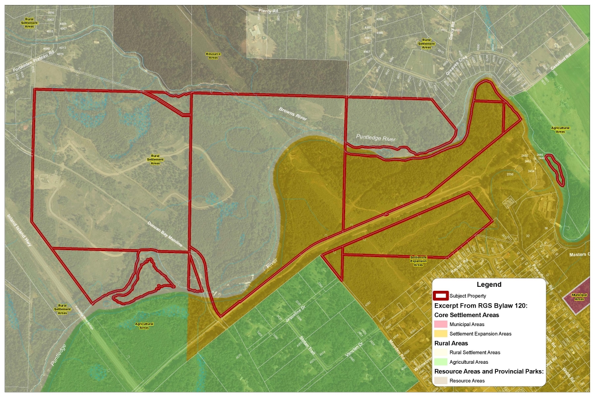
The RGS designation for the 3L Development lands are:
-
The lands that 3L owned before adoption of the current OCP in 2014, are designated under the former OCP bylaw 2042 as “Rural Area”.
Excerpt from Rural Comox Valley OCP Bylaw No. 2042, 1998:
C.1 Rural Area Objectives
- C.1(a) To encourage land use patterns which minimize urban sprawl.
- C.1(b) To ensure that development is serviced to an appropriate and adequate rural standard.
- C.1(c) To support land use proposals that minimize potential negative impacts on the natural environment and the productive potential of resource lands.
- C.1(d) To support the provision of affordable housing appropriate to its rural setting.
C.2 Rural Area Policies
- C.2(a) Lands designated as Rural Area are shown on Schedule B.
- C.2(b) Uses permitted on lands designated Rural Area are shown on Table 1.
- C.2(c) Where community water systems and/or community sewer systems are not available, lands in the Rural Areas shall only be subdivided in accordance with the regulations of the authority having jurisdiction for septic system and well approvals and in accordance with the minimum and average lot sizes provided in the applicable zoning bylaw.
- C.2(d) The strata conversion of secondary suites, carriage houses and secondary dwellings shall not be supported.
- C.2(e) The strata conversion of second dwellings shall only be supported where the minimum lot size requirement is achieved.”
- C.2(f) Despite any other provision of this bylaw, density averaging, density bonusing and density transfer do not apply to the subdivision of lots within areas designated as “settlement expansion areas” under “Comox Valley Regional Growth Strategy Bylaw No. 120, 2010. Density averaging, density bonusing or density transfer may be used to secure community benefits such as the preservation of rural lands, open space, sensitive habitats, and working woodlots.
- C.2(g) Settlement adjacent to ALR lands shall provide buffering and appropriate and adequate servicing to reduce potential negative impacts on farm land.
-
C.2(h) The annexation of land in the Plan area into the municipalities of Comox, Courtenay and Cumberland by means of boundary expansions may be supported where such urban expansion occurs within mutually determined containment boundaries or because of verified public health and safety issues. Phasing of such boundary expansions, based upon projected five to 10 year land requirements, shall be encouraged as a means of lessening the impact on rural residents.
OCP Bylaw No. 2042, 1998
OCP Schedule C Bylaw No. 2042, 1998
Lands acquired by 3L after November 2014 are subject to OCP bylaw 337 which designates those portions as either rural settlement area or settlement expansion area.
-
The majority of the lands are zoned Rural – Twenty (RU-20). The following land uses are permitted:
- on any lot:
- agricultural use
- fish hatcheries
- residential use
- garden nurseries
- vet clinics
- silviculture
- on any lot 2.0 hectares or larger:
- animal kennels
- riding academy
- on any lot 4.0 hectares or larger:
- wood processing;
- sawmills;
- gravel, mineral or peat extraction, gravel crushing and screening but no manufacturing or sales of concrete or concrete products.
- On any lot 4.0 hectares or larger AND which is classified as private managed forest land or farm (classified by BC Assessment Act) or is within a licensed area under the Forest Act:
- Research and teaching facility;
- Rural resource centre (maximum floor area 300m2)
The minimum parcel size for subdivision is 20 hectares (50 acres).
One portion of the lands (adjacent to Crown land) is zoned Upland Resource 40 hectares (UR-40).
- on any lot:
-
No. These are the zoning maps that have historically pertained to the 3L lands: Zoning Bylaw 314 -1978, Zoning Bylaw 597 - 1982, Zoning Bylaw 869 - 1986, Zoning Bylaw 869 - 1995 Zoning Bylaw 2555 - 2003, Zoning Bylaw 2781- 2005.
-
At the Committee of the Whole held March 12, 2013, 3L Development Inc. presented an offer to exchange 81 hectares of land around the Puntledge River area, including Stotan Falls, for $9 million plus development-related conditions. On March 26, 2013, the Regional Board met to consider the offer but declined.
-
In May 2013, 3L Development Inc. applied to amend the Regional Growth Strategy to create a new Settlement Node (proposed to be named Riverwood) on their properties suitable to accommodate approximately 741 houses, commercial space, and 74 hectares of park land. The Regional Board considered the application on August 20, 2013, but referred further consideration to a future meeting. On June 24, 2014, the Regional Board considered the proposal again but resolved not to initiate the amendment to the Regional Growth Strategy.
-
Following the Regional Board’s decision to not initiate the amendment to the Regional Growth Strategy, 3L Development Inc. sought a legal review through the court system. On May 6, 2015, the BC Supreme Court concluded that the CVRD did not correctly process 3L Development Inc.’s application. The decision was upheld by the Court of Appeal on April 6, 2016. The courts did not assess the merits of the application, only the procedure used by the CVRD to process it. The court ordered the CVRD to process the application again.
-
Following the instructions of the BC Supreme Court, the Regional Board met on July 24, 2018, to consider whether the 3L Development application to amend the Regional Growth Strategy constituted a standard or minor amendment as defined by Part 13 of the Local Government Act and to consider whether to initiate the amendment. The Regional Board resolved to initiate the amendment process and that it be considered a standard amendment. On August 14, 2018, the Board adopted a consultation plan to consider the amendment. Following a public consultation period which included an open house, the Regional Board met again on October 2, 2018, and based on the comments and recommendations received, as well as the recommendation of the RGS Steering Committee, the Regional Board refused the application.
-
In 2020, 3L Development Inc. again made an application to enable subdivision and development of the lands. The revised Riverwood concept included 335 residential lots plus additional lots for multi-family units, townhouses, commercial space and 97 hectares of park land. The Regional Board reviewed the application and decided to issue referrals concerning the application to external agencies, such as the municipalities and First Nations, for comments and recommendations based on their interests, as well as CVRD advisory planning commissions. Upon consideration of these comments and the objectives and policies of the Regional Growth Strategy and Official Community Plan, the Regional Board refused the application at its meeting of November 24, 2020. However, the Regional Board also adopted the resolution "that staff be directed to work with 3L Developments Inc. towards securing public access to Stotan Falls."
-
Opportunities for the CVRD to acquire land park or conservation purposes through the land use planning process arise at the time of rezoning (i.e. voluntary community amenity contribution by a developer) and/or subdivision (requirement of the Local Government Act to dedicate lands or cash in an amount up to 5% of the market value of the lands proposed for subdivision). The CVRD can also approach land owners to negotiate purchase of lands independent of a land use application.
-
In certain limited circumstances, the Province can request that land be “returned to Crown” at the time of subdivision or development permit.