

Updated December 5, 2023:
The Royston Seaside viewing platform is closed until further notice due to structural issues.
History
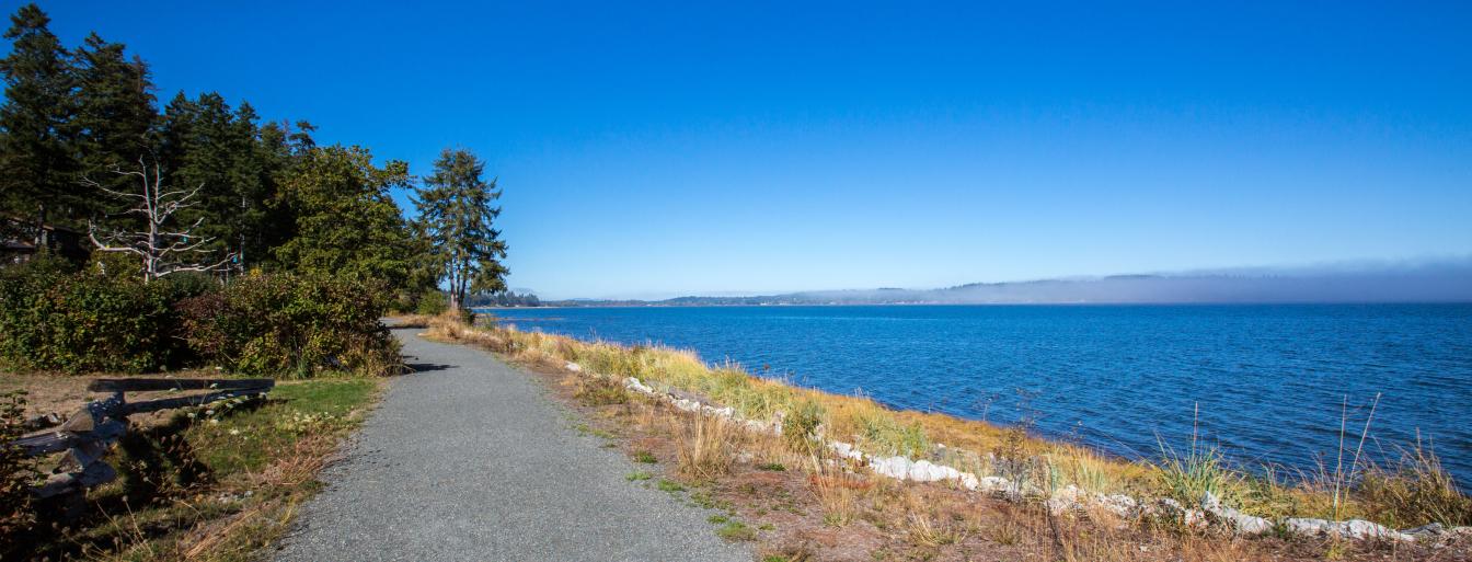
Marine Drive section
Royston wharf handled a heavy tonnage in oil products through the years. Initially barrels of oil were rolled to shore on the wharf. Fuel was later pumped from barges to tanks on the Royston waterfront. Oil tanks were located on the northwest corner of Royston Road and Marine Drive from 1916 until 1997. The wharf head was 12 m x 30 m (40 x 100 ft) with an approach that was just 1.1 m (3.6 ft) wide but 400 m (1,320 ft) long.
The licence for this wharf was transferred to the Comox Valley Regional District (CVRD) from Shell Canada in November 2000. In 2003, the wharf was removed and a viewing platform was built. In 2013, the CVRD obtained a Ministry of Transportation and Infrastructure (MoTI) permit for the portion of accreted lands between Marine Drive and the foreshore and a 30-year License of Occupation for the southwest portion of DL 184, Nanaimo Land District. This parcel includes an approximate 10 metre buffer around the viewing platform.
In 2015, the picnic area was redone with new tables and an accessible path with grant funding. The CVRD added a BBQ shelter at the Marine Drive picnic area between Warren and Ross Aves in 2018. The new shelter replaced a stone BBQ the community built as a BC centennial project in 1971. Plaques from the 1971 BBQ are featured on the new structure.
Breakwater Esplanade section
The tenure for this section includes a MOTI permit and a Recreation Sites & Trails BC Partnership Agreement which will expire in March 31, 2024.
The trail between the bottom of Lince Road and Chinook Road follows the former Comox Logging railway right-of-way (the road right-of-way is called the Breakwater Esplanade). Starting in 1911, steam locomotives hauled logs from logging camps throughout the Comox Valley to the Royston log dump. The logs were sorted into booms and towed to more protected waters on the inside of Goose Spit. From there, the steam tugs towed the log booms to Fraser Mills in New Westminster. Where it approaches Hilton Road, the railway grade was constructed in the intertidal area. From the end of Chinook Road, a mile long wharf extended into the water. Logs were tipped off the wharf until the early 1950s when the railway stopped running.
Starting in 1937, large sailing ships and tugs were sunk off Hilton Road to protect the exposed log booming grounds. The wharf was taken down and replaced by a breakwater in the 1950s. Logs were stored north of the breakwater until 2005. The rocks that can be seen within the intertidal area during low tides most likely originate from the fill material placed to construct the railway grade.
The railway grade eroded over time. Erosion accelerated in particular after the log storage in front of the breakwater was taken out in 2005. Neighbours to the trail approached the CVRD and the MOTI repeatedly to repair the trail. In 2012, the CVRD received funding from the Province to help fund reconstruction of the trail which was re-constructed in fall and winter 2013/2014.
Prior to Europeans arriving coastal First Nations used the beaches in the Royston area they called Tle-Tla-Tay to dry smoked herring and herring roe. They would hang fish on frames to catch sea breezes and dry the roe on tree boughs.
Information
The northern half of the Royston Seaside Trail is built on a portion of the old Comox Logging Railway Grade known as “The Breakwater Esplanade.” The southern half of the trail follows Marine Drive. Marine Drive offers great views across Comox Harbour. With a stone fireplace and six picnic tables it is a premier spot for a BBQ with friends and family. Children will love the playbox and exploring the beach. The picnic area is between Warren and Ross Aves just north of the viewing stand located at the end of Royston Road.
Accessibility
Royston Seaside Trail, between the Hilton Road parking lot and heading north to Chinook Road, is accessible for those with mobility issues. The picnic area and viewing stand on Marine Drive are also accessible.
Location
- Royston waterfront between Chinook Road (turn at 3650 Island Highway) and Lince Road continuing along Marine Drive until Ronald Avenue. The main parking area is at 3768 Hilton Road. The BBQ picnic shelter is located at 3984 Marine Drive.
- Baynes Sound – Denman/Hornby Islands (Electoral Area A)
Park Etiquette
- Leashing is mandatory in this park, all year